
Peninsular Region
- The origin of rocks of Peninsular India is more than 3600 million years
- A part of Gondwanaland prior to Carboniferous period
- During Carboniferous period coal was formed in Damodar, Son, Mahanadi and Godavari basin
- For around 146 million years back during Cretaceous period large scale of volcanic activity led to the formation of Deccan Trap
- Highest rainfall in World is recorded at Mawsynram
- Gersoppa or Jog Falls, highest waterfalls of India in Sahyadris
- Highest Peak: Anaimudi(2695m)
Rock System
- Archaean Group : These rocks are originating from Precambrian period. The Bengal gneiss is known as Khondolite.
- Dharwar System : These are the oldest metamorphosed sedimentary rocks
- Cuddapah System
- Vindhyan System : The historical monuments like Stupa of Sanchi, Agra Fort, Red Fort, Jama-Masjid etc. have been constructed with red sandstones obtained from Vindhyan ranges.
- Gondwana system
- Deccan Trap : The eruption of lava was of Hawaiian type of fissure type.
- Tertiary system : The last phase of fragmentation of Gondwanaland happened during tertiary period. Faulting of peninsular block occurred
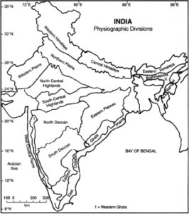
Regional classification
- Chotanagpur Plateau : It stretches over Purulia and Santhal Parganas of West Bengal. The area with highest elevation is called Pat land. Barakar, Damodar, Subarnarekha, Koel etc. are the major rivers draining the region
- North Deccan (Maharashtra Plateau) : The region is majorly composed of basalt rocks and is comprised of Mahanadi Basin, Chattisgarh plain, Garhjat hills and Dandakaranya
- South Deccan : The region is comprised of Telengana plateau, Karnataka plateau and Tamil Nadu uplands
- Western Ghats : Also known as Sahyadris is comprised of several important passes like Palghat or Palakkad pass, Bhor Ghat, Goran Ghat, Haldighat also famous for historic battle between Rana Pratap Singh and general of Akbar in 1576. Major rivers flowing from Western Ghats and draining into Bay of Bengal are Godavari, Kaveri, and Krishna etc.
- Eastern Ghats : They are also known as Mahendra Parvatam. It also receives the benefit of being the water shed for the rivers originating in Western Ghats.
- Meghalaya plateau and Mikir hillls : Meghalaya plateau is detached from Deccan by Malda fault. Shillong Peak(1823 m) is the highest peak of the region while Nokrek (1515) being the highest peak of Garo Hills. Cherrapunji and Mawsynram records the highest rainfall in world.
- North Central Highlands : It is comprised of Aravalli range which is the oldest plateau mountain of India. Guru Shikhar is the highest peak of the region.
- South Central Highlands : The range is comprised of Vindhyas which is intermingled with Indian mythology and history. The earliest known multicellular fossils of eukaryotes have been discovered from this basin. Sadbhawna Shikhar is the highest point of Vindhyas. Several rivers originate from Vindhyas like Narmada and Son from Amarkantak of Maikal hills. Chambal, Betwa are other important rivers of the place
Significance
- The region is rich in metallic and non-metallic minerals. 98% of Gondwana coal is found in this region
- A considerable part is covered with Regur or black soil suitable for cotton production
- Predominance of Dravidian culture is found to the south of Vindhyas
- The region is rich in medicinal plants along with teak, fuel wood and sandal
- Ample scope of hydro-electric power generation for deep gorges in Western and Eastern Ghats.
Himalayas and its associated fold mountains
Origin of Himalayas
- Geosynclinal origin
- Plate Tectonic origin
The Himalayas consists of four lethotectonic mountain ranges
- The Trans Himalaya or Tethys Himalaya: A 40km wide belt consisted of marine fossilized Tethys sediment underlain by tertiary granite
- The Greater Himalaya: A 25km wide belt with average elevation of 5000m above sea level consisted of almost all the highest peaks of the world.
- The Lesser Himalaya: A 80km wide belt with average elevation ranging from 1300m to 5000m above sea level. The region is subjected to extensive erosion for heavy rainfall, deforestation and urbanization
- The Shiwalik or Outer Himalaya: average width of 8km in east to 45km in west with elevation of about 1300m above sea level. Between Siwaliks and Lesser Himalayas longitudinal valleys of Duns are found. Among them important duns are Dehra Dun, Kothri, Kathmandu, Chumbi etc
Himalayas takes southward syntaxial bend one in west near Nanga Parbat and the other in east after Brahmaputra valley as shown in above fig.
Prof S.P. Chatterjee, divided Himalayas in following transverse sections:
- The Kashmir Himalayas: With an average height of 3000m above sea level, it has the largest number of glaciers in India. Ladakh region of Kashmir Himalaya characterizes the cold desert condition. Karewa is a special feature of Kashmir Himalayas where cultivation of Saffron is famous along with orchards of apple, peach, almond, walnut etc. Pir-Panjal, Bani-Hal, Zoji-La, Chang-La, Qara-Tagh-La(Karakoram range) are important passes of this region. Nanga Parvat, and K2(Karakoram) are important peaks of this region.
- The Himachal Himalayas: All the three ranges of Himadri, Himachal and Siwalik are well represented in this region. The northern slopes are bare with plains and lakes while the southern slopes are forested. Rohtang, Bara-Lacha, Imish-La, Shipki-La are important passes of this region. The region is famous for hill stations like Shimla, Manali, Kullu, Chamba, Dalhousie etc. and was also the favorite place for British rulers for it spice rich gardens
- The Kumauni Himalayas: It lies between river Sutlej and Kali.Its highest peak is Nanda Devi(7817m). Kamte(7756m), Trishul(7140m), Kedarnath, Badrinath are other important peaks of the region. Gangotri, Minar, Pindari are the main glaciers of this region. Mana Pas, Niti Pass, Tun Jun La, Shalsal are important passes of the region.
- The Central and Sikkim Himalayas: It lies between river Kali in west and Teesta in east. It is comprised of all the three ranges of Himalaya and is consisted of the highest peaks of the world Mt Everest(8848m), Kanchenjhunga(8598m), Makalu(8481m), Dhaulagiri(8168m), Annapurna etc. Nathu-La, Jelep-La are important passes of this region.
- The Arunachal Himalayas: It stretches over Bhutan, Arunachal Pradesh over the plains of Assam. Aka, Daphla, Miri, Abor, Mishmi hills comprise this region with Namcha Barwa. Bomdi-La, Tse-La, Dihang are important passes of this region
- Purvachal Himalayas: Here the ranges are aligned in a north to south direction. The major hulls in this region are Patkai Bum(Arunachal Pradesh), Naga Hills, Manipur Hills, Blue Mountains of Manipur, Tripura & Brail ranges. The extension of Myanmar mountains continue over Andaman and Nicobar islands up to Indonesian archipelago.
Major Himalayan Passes:
- Aghil Pass: It joins Ladakh and Xianjiang province of China with an elevation of 5000m above sea level in the Karakoram range to the north of K2.
- Banihal Pass: Also known as Jawahar Tunnel for round the year surface transport joins Jammu with Srinagar in Pir Pnajal range is at a height of 2832m
- Bara Lacha: Its being transformed into national highway connecting Manali with Leh at an altitude of 5045m.
- Bomdi-La: It connects Arunachal Pradesh with Lhasa, the capital of Tibet. It is at an elevation of 2600m. It has immense strategic significance.
- Burzail Pass
- Chang La Pass : The pass has a temple dedicated to Changla Baba after whom the pass is named. It connects Ladakh with Tibet.
- Debsa Pass: Its an alternate route between Kullu and Spiti from traditional Pin Parbati Pass.
- Dihang Pass: It connects Arunachal Pradesh with Myanmar.
- Khardung La Pass: With an elevation more than 6000m above sea level, it is the highest motorable pass of the country.
- Jelep La Pass: Connecting link between Sikkim and Lhasa through Chumbi valley
- Likhapani Pass: The connecting pass between Arunachal Pradesh and Myanmar at a height of 4000m above sea level, it remains open through out the year to carry out trade and commerce between the region.